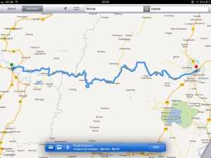
Before I leave this morning, I find that I am 11,000 miles from home. Google maps tells me that it would take about five days and 20 hours if I headed back now. This does, of course, assume that I will be doing the state speed limits and didn’t stop much [Or at all!], but my lovely camper is too nice to trash.
Instead, and in the true spirit of the journey, I leave Silchar just before 10:00 and head out of the top of the city and onto the NH53 east to Imphal. I fill up the tank, buy some fresh fruit for the drive and head off. After a few twists and turns, I realise that there are mountains ahead.
I roughly follow the winding Borek river that I crossed yesterday. At Lakhipur I stop and watch the ferry head across the river. This is a small, but busy town and a number of ferries move all sorts of things from one side to the other.
As I head up into the Manipur hills, the roads become more gravel-based. It’s noticeably cooler up here. The hill region is classed as a sub-himalayan range and forms a very neat ring around the capital city, Imphal. The highest in the range is over 12,000 ft. (Approx. 3,600 m.) As I head up the road, I am already in the lush forest that line the mountains. Most of the road is at an elevation of 500 to 700m, and the sharp ridges are paired with steep drops on many sides. I wind around the peaks and meet the occasional river. It’s dry today, and I am happy with that, given that the roads are nothing more than open gravel and the occasional steep drop-away. This time of year tends to be largely dry, with May/June being the hottest months. I meet a number of military convoys along the road and let them pass. The area has quite a story to tell.
The game polo originated in Manipur. British soldiers and planters took it back to England, changed the rules a little and made it popular around the world.

