Hanoi, here I come

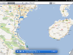
Big journey today. The plotted route on Google maps gives me three possible routes and I choose Route 3 for no other reason than it follows the coast all the way up. There’s less than half an hour between the routes, and I fancy having the wind in my hair. If I had any hair, that is.

A coastal journey along the South China Sea.

So I have the earliest breakfast the hotel can give me and I head off to give the camper a check over. Dong Hoi is actually quite nice. Dong Hoi is the capital of the Quang Binh region, and the estuary adds a seaside feel to the whole place and fishing is clearly one of its main industries.

My hotel is just there to the right.

Very picturesque.

In 1926, a French female archaeologist, Madeleine Colani discovered many items in caves in west Quang Binh. With Carbon14 tests, the artefacts were dated back to 10,509 years ago.

Now, I have to say I have a bit of an interest in things dating back to 10,000 BC, or there a bouts. This seems to come up an awful lot in ancient history and is largely seen as the starting point of the warming of the Earth and the end of the Glacial period. In popular culture, Atlantis was destroyed about 9,600 BC. Some people even suggest that an Alien race set up shop around this time in various parts of the world, but that’s for another day.

I head north and find my virtual self on the AH01 again, which is actually quite comforting. Vietnam drive on the right, which is fine, but I do have to pay attention on junctions. In fact, almost all of the countries that drive on the left are old British Colonial states. Practically every other one drives on the right. (You can always check using whatsideoftheroad.com. It seems to be accurate, but second check if it’s important.) For safety sake, if you are a British citizen, like me, register with the Foreign Office’s LOCATE system. Many other western nations have similar systems that allow a quick response if you get into trouble as a traveller. While I am on the subject, the British Foreign Office tell me that there are no current travel restrictions in Vietnam for me.

It takes me almost three hours to get to Vinh, another estuary city on the coast. I cross the Vinh bridge and into the city. In the 1950′s, much of the original city was destroyed in the countless battles between the French and the Viet Minh, which means the city I pass through is mostly modern. As I leave Vinh to the north, I drive into Cua Lo, one of the most popular resorts in this part of Vietnam.

The estuary port.

The Vietnam seaside resort.

One thing I notice about the last few countries I have been through, and that’s how many bridges I get to cross. I barely get a few hours before I have to cross another one. Having the sea on my right is not helping, and I cross another 14 before I arrive at Hanoi. I ‘book’ a room in the Rising Dragon Palace Hotel for £35, just a mile form the railway station and views of Hanoi’s Old Quarter. My camper goes into the parking bay and I take an overnight bag. I plan on staying in Hanoi to take the time to look around, get a feel for the city and find some great history.

Posted in Enroute | Tagged | Leave a comment

Over the Trail to Dong Hoi

I am driving over the much fabled Ho Chi Minh Trail. This stretch of mountains became one of the most important corridors the Vietnamese could have wished for. The U.S. National Security Agency once referred to the Trail system as “one of the great achievements of military engineering of the 20th century.” Along these mountains, the National Front for Liberation of South Vietnam, or the Vietcong, as the US forces referred to them, supported their cause. The Trail has its origins in early trade routes in these parts, but by the end of the Vietnam war, it had became an elaborate network of roads, storage areas, barracks and command facilities.

Route 9, or AH16, takes me over the range and between the peaks. Most of which are around 600m. The Song Thach Han river is below me to the right, as it heads east and then south towards Dong Ha and the south china sea.

The Song Thach Han river

In 1941, Ho Chi Minh (Born Nguyễn Sinh Cung in 1890.) returned to Vietnam to find it occupied by two foreign states: Vichy France and Japan. He had travelled the world, spending time in London, France and the United States. Not the peasant I always thought he was. He took control of, and developed what was to become the People’s Army of Vietnam (PAVN), and declared the independence of Vietnam in 1945. (I found an interesting similarity here to how the formation of the US came about, when a group of men met in secret to do the same in 1776.) The new declaration was contested by the US and other nations in that it was based on a Communist government. This was the start of the cold war, and Communism was not a popular way to go.

Over 58,000 US servicemen died in the war, but that doesn’t come close the estimate of between one and three million Vietnamese soldiers and civilians, 200,000 – 300,000 Cambodians and 20,000 – 200,000 Loatians. The Vietnam war is now the example of how not to conduct a war.

Once over the mountains I head down towards the sea and Dong Ha. It’s another two hours before I arrive at Dong Hoi. The sight of the South China Sea is the first expanse of water I have seen since the Black sea in north Turkey, and it’s a wonderful sight. I ‘book’ a room for the night in the Moon Light hotel, right on the mouth of the estuary and facing the sea. Now to look for something nice to eat.

Posted in Enroute | Tagged , , , | Leave a comment

Junket across Laos

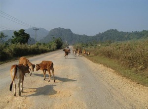
I headed out onto the AH16, still part of the Asian network I have mentioned a few times, that cuts a line across this part of Laos towards Vietnam in the east. The Laos people seem to be pretty relaxed about everything. Every so often I get an intersection of roads where there are no traffic lights or policeman waving people this way and that. Instead, we all just weave around and get by. No bibbing of horns or road rage. I am noticeably over polite, and am always the most interesting sight on the road.

Not always whizzing along a road.

Great way to travel.

After the Geneva Conference in 1954, France eventually relinquished their hold over these countries and they became independent. To this aim, Vietnamese nationalists fought for a unified country under a Communist government, but the United States, along with the help of south Vietnamese, wanted to stop Communism wherever they found it, almost by any means. By the mid 60′s, the Vietnam war reached a new level, despite the US Government losing all support from the American public. Laos used a number of political agreements to try to stay out of the war, but after a major invasion on the Plain of Jars, it was inevitable that Laos was now part of the conflict. The US used most airfields to mount attacks on the neighbouring country. Massive aerial bombardment was carried out by the United States. The UK newspaper, The Guardian reported that Laos was hit by an average of one B-52 bombload every eight minutes, 24 hours a day, between 1964 and 1973.

I stop off at Phin to fill the tank and pick up some food. (Here’s a thought. Not all Petrol stations have all of the fuel types you might need. For instance, some only have leaded petrol, so many modern vehicles, which require unleaded fuel, may well have a problem. My habit of topping up when I can seems to be the best approach.) There are plenty of reminders of the war on this route, and I go and see the monument-like remains of the American helicopter in Muang Phin. As I carry on I head up into the Annamite mountain range that forms the border between Laos and Vietnam, I travel through a long valley and beside a river and it’s not long before I get to the Dansavan/Lao Bao border crossing. There’s a bit of a queue, and as far as I can find out the border is only open between 08:00 and 17:00. It’s only a little after two, so I should have plenty of time. I am heading to Dong Hoi, which is another two and a half hours drive. Again, I get a Visa on Arrival (VOA) into Vietnam, which costs between US$30 and US$40, depending on your natioanlity. This I find interesting, but can’t find the reason for different costs.

It takes about an hour and I pass through as part of a small convoy of similar-sized vehicles, through the Laos border arch, along the short road and through the Vietnam arch. Lao Bao, on the other side is much smaller than I thought it would be, but I have no time to stop and take a look.

Posted in Enroute | Leave a comment

Leaving Savannakhet

I have learnt a great number of things about this city, the people and its culture. Before I leave Savannakhet, I want to share a video I found.

[youtube http://www.youtube.com/watch?v=DqzuSzs3cSQ?rel=0]

Posted in Enroute | Leave a comment

Day 47: Savannakhet

I find myself in the second largest city in Laos, with a population of over 120,000 and a mix of Lao, Thai, Vietnamese and Chinese.

The city has its own airport, which is served by Lao airlines, and is a wholly-owned carrier of the single-party Socialist Laos Government. A rather dubious reputation for safety, the airline has lost a number of flights over the years. If you can’t afford to get across land to see Angkor wat, or need to get to Bangkok in a hurry, Lao airlines will get you there. So, take this word of advice if you fly with them: Lao airlines mainly use two type of aircraft, the French-built ATR-72 and the Chinese-built MA-60. Let’s just say you should make sure that you fly on an ATR-72.

Lao Airlines have never crashed an ATR-72.

Not quite the same success with an MA-60.

At the end of the Vietnam war in the mid 70′s, the US airforce flew in regular C-130s in their investigation of soldiers reported as missing in action.

I head along to the old French colonial part of the city, which is now rather sad and dilapidated. The French had first entered these countries in the 1850s, forming French Indochina, having taken parts of Vietnam and Cambodia. Laos was added in 1893. France released the peninsular after the Geneva Conference in 1954 and events after these agreements later formed the basis of the United States’ involvement and later still, the Vietnam War. The city now spreads out around the old part and there is very little left.

Like a ghost town.

And hauntingly beautiful in places.

As it starts to get a little dark I head towards the Mekong river bank, just a little north of the city and get a table in the Lao Lao restaurant. Here I am in Laos and I end up in a Thai restaurant, but this is good food with a cold beer. As the sun goes down I look out over the river expanse and I’m already looking forward to the next stretch tomorrow.

Posted in Places | Tagged , , | 2 Comments

Across the Mekong river

Today I am up early, [which is just as well, because I couldn't sleep in the hot night.] to make my way to Mukdahan on the border with Laos. One of the things I am excited about today is that my virtual self gets to cross the Mekong river. It’s a more reasonable 28c today, and as I go a little more north, it looks like it will be lower from now on. Crossing at this point is not difficult, but the best advice is to get there early.

The bridge, known as the second Friendship bridge, is 1600 meters (1.0 mi) long and 12 meters (39 ft) wide, with two lanes for traffic. I have been driving on the left all through Thailand, but they drive on the right in Laos. This presents a bit of an issue on a bridge, so the cross over is only on the Thai side. I therefore have to remember to traffic onto the right. As long as the locals understand this rule, of course.

A ‘Visa on arrival’ system is reliably available at most overland crossings between Thailand and Laos, including the Huay Xai, Vientiane, Savannakhet (Where I am), Tha Khaek and Chong Mek entry points. Many border crossings have some form of departure tax, but there doesn’t seem to be one here. Now, a 30-day tourist visa for Laos should cost about US$35 depending on your nationality and the office you use. For reasons I couldn’t figure out, the fee for Canadians is about US$45. (Danger money? Extended insurance? I thought Canadians are supposed to be nice.)

I intend on being in Laos for about, ooh, four hours! But, as far as I can find out, I need a 30 day visa to do it in. (I suppose I could mill around for twenty-nine and a half days and make a dash to the other side, just for the hell of it! OK, maybe not.) All of the border visas are single entry, which is important to remember.

If you look carefully, you can see me!

Oh look! It's another Friendship bridge.

The Mekong river is very wide and a touch murky, but the view across the join of these two countries is incredible. Its estimated length is 4,350 km (2,703 mi). That’s longer than it is from New York to San Francisco. The river starts on the Tibetan plateau, and is the 12th longest river in the world and the 7th longest in Asia.

Looking back across the bridge at Thailand.

Once across the bridge I turn and head towards Savannakhet. It is mid afternoon and I could really do with a beer and a snack of some sort. I’l take a look around and tell you what to expect if you came here.

Posted in Enroute | Tagged | Leave a comment

Driving the Mittraphap road

It took a while to get out of Bangkok and find the right road. Bangkok is one giant sprawl, and the traffic would be a whole lot simpler if the locals followed the rules. Any rule, actually. I find myself back on the AH1 for a short time before taking Highway 2, which takes me north east, passed Nong Khae, where I fill up the tank, and onto Pak Phriao, where I turn on to the Mittraphap Road.

Mostly flat and hot.

Did I mention hot?

This is one of four major artery roads in Thailand, and this one was built with the financial assistance of the United States. In fact, it is the first road in Thailand to meet international standards, and the first to use asphalt and concrete. The temperature has reached 36c today and I am only about two thirds of the way to my destination in Phayakkhaphum Phisai. When I get to Mueang Nakhon Ratchisima, I pull over and buy a few things, including water. Nakhon Ratchasima has long been the most important political and economic center in the northeastern region, and it became an important air base to the United States during the Vietnam war in the late 60′s and early 70′s.

The area around Korat was already an important center in the times of the Khmer empire in the 11th century, and the larger empire stretched from southern Burma, in the west, to consume modern Laos, Cambodia and much of Vietnam in the east. There is nothing more impressive about their empire than the city of Angkor in modern Cambodia.

I take the right turn at Sida and onto the 202 towards Nong Yueang. I eventually drive into Phayakkhaphum Phisai late afternoon and find a good place to park up. (I did find a number of hotels in the town, but none of them could be booked online, so the camper it is.) I go into the main street to find a store, which is rewarded with finding a very cheap restaurant where I eat for a very reasonable price. It’s still pretty hot and I am not expecting it to get much cooler than about 25c, so it might be a restless night.

Posted in Enroute | Tagged | Leave a comment

Day 45: Bangkok

This morning, after a decent breakfast, I headed off into the bustle of the streets to see what I could find. I don’t think it dropped much lower than 24c last night, but my room had air-conditioning, so I had that on. Left me with a bit of a thick head, but it soon went.

It is pretty obvious that you have to be nuts to drive here, especially as a tourist or ad hoc visitor, so I thought I would see what the transport system was like. It’s mid morning and already about 28c, so I pick up some water in a shop and head towards Ramkhamhaeng station across the road. The first thing with these transit systems, and it’s fair to say this for any of them, is that you don’t know where anything is. Thankfully, the map is in both Thai and English, so if only I can match the name to something I want to see!

Colourful, but not entirely helpful.

I make my way west and to the old city of Thunburi. Bangkok is seriously busy. I contemplated not bothering with the transit and just getting a cab, but that didn’t look like a sensible thing to do, considering how slow the traffic was.

With the sacking of Ayutthaya in 1767, King Taksin made his new capital at Thonburi and built the impressive palace near the bank of the Chao Phraya River. Its location made for a better defence, being closer to the sea and this became important in defending itself from frequent Burmese invasions. King Rama I moved the capital to Bangkok in 1782, but Thonburi remained independent until it was merged in to the ever-growing Bangkok in 1972. The Palace seems rather squeezed, but impressive all the same.

The Palace has been the official home of many Kings since it was built, and one particular king is better know as the inspiration for the novel Anna and the King of Siam. In 1861, King Mongut asked for an English lady to be the governess to the royal children. Anna Leonowens arrived with her five year old son, and the King, showing his progressive nature and understanding of world affairs, discussed these modern ways. The novel was published in 1944, based on the diaries of Anna Leonowens. The film was release in 1956 staring Yul Brynner and Deborah Kerr. Certainly one of my favourites.

King Mongut and his Prince

Yul Brynner. Not a King.

It would be wrong not to mention that Bangkok is renowned as the city where you can get anything, and I mean, anything. Prostitution is actually illegal in Thailand but that doesn’t stop the hundreds of massage  parlours, saunas and hourly hotels where this is readily available. I head down to the river and take one of the many boats that serve tourists and locals and sail up the river. Bangkok has an extensive canal system and has often been referred to as the ‘Venice of the East’. Unfortunately, although there are still many markets that still trade along the banks, the canals are heavily polluted. The boat comes out into the main river, which was a surprise to me as I thought I was on the river, not a canal, and I get off the boat at Tha Chang Pier and find a very nice restaurant called Supathra River House. It’s only just after six, but I thought an early dinner would be nice and to spend a couple of hours overlooking the river.

By the time I get back to my hotel I am shattered. I have a long drive north tomorrow, so I’ll take a shower, get some sleep and be fresh for the morning.

Posted in Places | Tagged , , , | 1 Comment

South to the City of Angels

My journey south today is only about three or so hours, but the ultimate destination in Thailand has to be Bangkok. I pass through Ang thong district, which has over 200 magnificent temples. There are no mountains or forests on this stretch, and the land is largely agricultural. Rice is the majority produce, and some very elaborate canals feed the fields with water from the two rivers that run through the district.

I pass into the next district on the AH2, which is the historically important, Ayutthaya. Ayutthaya was the capital of Thailand (then known as Siam) for 417 years from 1350 until 1767, when the Burmese army invaded. In the late 1600′s, the kingdom, then ruled by King Naresuan the Great, became one of the biggest traders in the south seas and even had connections with a number of European countries including Louis XIV of France.

It’s warm today with a high of 27c, but the big problem for me is the 84% humidity. My camper doesn’t have a modern air conditioning system, so rolling down the windows just isn’t cutting it. There’s a heavy cloud cover with few breaks, which is making things look a little grey.

It is just after midday when I head into Bangkok. With a population of 14 million, according to the 2010 census, it is one of the most densely populated cities in the world. I have decided not to waste this opportunity and will stay over and spend tomorrow taking in the city, its food and culture. I have ‘booked’ two nights in the Nasa Vegas Hotel using Booking.com. It’s fairly central and not too far back from the coast.

Posted in Enroute | Leave a comment

Along the Ping river

As I travel south on Highway AH1, it isn’t long before I find myself following the Ping river on my left. This is the main river in the Kamphaeng Phet Province. The region had its own royal city as early as the 14th Century, but was known then as Chakangrao. I am particularly taken with the idea that this area of Thailand is a big supplier of bananas, and a banana festival is held every year to thank the gods for the harvest.

Ayutthaya was a Siamese kingdom that existed from 1350 to 1767 in this province. Siam was the ancient name of this country until 1939. Interestingly, it was restored to the name of Siam between 1945 and 1949, but has been Thailand ever since. The oldest known mention of their existence in the region by the exonym Siamese is in a 12th century A.D. inscription at the Khmer temple complex of Angkor Wat in Cambodia, which refers to syam, or “dark brown” people.

As I drive on and into Mueang Nakhon Sawan, my final destination for today, I notice that Google maps indicates that this last stretch of the road is both AH1 and AH2. Can’t find anything to clarify this.

Mueang Nakhon Sawan is the capital province in this area. The main rivers of the district are the Nan and Ping, which meet in the town of Nakhon Sawan to form the Chao Phraya. In the eastern part of the district is the Bueng Boraphet swamp, the most important wetland of the whole province.

I ‘book’ myself a hotel for tonight, as my virtual self could do with a good hot shower and a straight meal. I ‘book’ a room in the Bonito Chinos Hotel. it has good reviews and a good parking area for my travelling friend. I will eat in the restaurant and get a good night’s sleep. Tomorrow, Bangkok.

Posted in Enroute, Places | Tagged , | Leave a comment