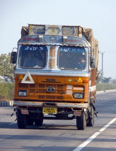
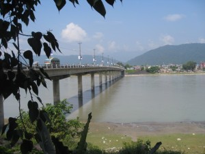
Views of Dhaka

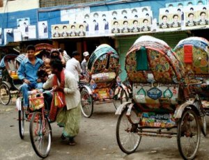
Dhaka, with it’s greater metropolitan area, is the 9th largest city in the world, with a population of over 16 million. This place is the king of the rickshaw, with over 400 thousand trading throughout the city. Although the city dates back to the Mughal rule of the 17th century, there are settlements that take it further to around the 7th.

The sheer amount of people and traffic is almost overwhelming. On my way into the city, I felt I was dicing with death on every turn, and a few cyclists bumped off the van as they bustled through. They don’t even seem to pay much attention to the traffic lights either, which a strung up high.

More rickshaws than you can wave a stick at.

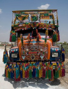
Every painting tells a story.

I took a short walk last night to look around the area the hotel is in. Around the corner I walked towards the junction on Rommna road and Kazi Nazrul Islam Avenue and the park that held the Shika Chiranton. This is where, in December 1970, the Pakistan army surrendered and the Bangladesh nation was born. This date was the culmination of nine months of bloody battle and the arrest, torture and murder of thousands of people in what was the war of independence. East Pakistan became Bangladesh.
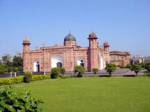
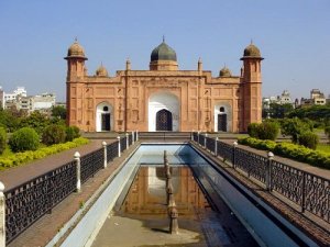
Dhaka rose up during the Mughal empire. During their reign, and the rulers since, impressive monuments of all kinds were built. Dhaka is known as the city of Mosques, but some of the earlier buildings stand out. Aurangabad Fort, or Lalbagh fort, as it is commonly known, is one of them. Located in the old city, it overlooks the Buriganga on the northern bank where is stands.

I am constantly watched and approached. Beggars follow me, a girl tries to sell me dodgy looking water in an Evian bottle. Another with a handful of sad flowers. Most are simply after money. There is rubbish along the side of most roads and the sewage is open. There’s plenty to smell and see, and it is humbling to think that we live in such well managed cities in the west. It makes you wonder what the Governments think of here. Walking at night is probably not a good thing to do, and I headed back to the hotel, had something to eat and retired to my room.

This morning I am up early again to head north east, but I take the N1 out and N102 north. As I cross the Meghna river, which is to the east of the city, I see the Magna Power station. The official name of the highway bridge I cross is Japan Bangladesh Friendship Bridge, but it is popularly known as Meghna Bridge and was opened in 1991. The river seems to split in every direction and the land is so low I can see how the water spreads out so easily during the monsoon season.

Posted in Places | Tagged , , | Leave a comment

Day 35: Rajshahi to Dhaka

Despite the rather ‘business’ type hotel and room, I sleep fairly well and am up nice and early. I have never been one to lie in bed until midday, and I really don’t understand people who go to new countries and sleep through it. I know that most people are going abroad for a holiday, but surely they are also there to get involved in the culture and history. Or is that just me!

About five years ago my family headed to Majorca for a week’s holiday. It was just the need to get away, and I don’t think we picked the destination other than it was cheap and sunny. We were staying in a non-descript, modern hotel, but the coast was great and there was a pool for the children, but we found ourselves constantly on the lookout for a good Spanish restaurant. We didn’t find one, as the whole island seemed to cater for people who just wanted a sunny, warm version of home. I have no idea why someone would like to do that.

Bangladesh was previously known as East Pakistan. [And West Bengal, previously to that.] I found this little snippet of history a little hard to understand, given that there is a large country in between here and Pakistan. This came about during the demise of the British Empire, and the nation was established with the partition of Bengal in 1947. Due to political exclusion and economic exploitation by the politically-dominant West Pakistan, popular agitation grew against West Pakistan and led to the Bangladesh Liberation War in 1971, after the declaration of Independence on March 26, 1971. Despite a troubled past, recent changes in its economy and management, it is seen by some high-level investors as one country to watch out for in the future.

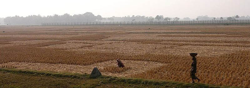
I take Highway N6 towards Natore and the Brahmaputra river directly east. The terrain is mostly flat, but very fertile and it is no wonder that two-thirds of the Bangladeshi people are farmers.

Half way there and I get to the Jumana Bridge over the river Brahmaputra. It’s a toll bridge. [The toll for a large vehicle is Tk 1,400, a medium truck Tk 1,100, a small truck Tk 850, a large bus Tk 900, a small bus Tk 650, a car or jeep Tk 500 and a motorbike Tk 40.]. At this time of year, with a lot less rain to cause trouble, the river looks wide, but calm. The bridge was opened in June 1998 and is a multi-use design that includes both motor traffic and rail. The bridge also carries electricity and a gas pipeline. Talking about getting your monies worth. It has been designed to be Earthquake-proof, but some structural damage has been found in recent years that has meant a regulation for the number of vehicles crossing at the same time.

It’s a reasonably short distance to Dhaka and by the time I reach the outskirts I am still fresh and it is only 14:30. As I drive in, things get a little industrial, with large factories and pipes. I make my way to the Ruposhi Bangla Hotel, which is a bit expensive and costs the most so far, but is well placed and has space for the camper. The ‘booking’ is in USD, as are most hotels I have looked into. I think I might get a shower and see what the city is like.

Posted in Places | Tagged , | Leave a comment

Crossing borders

I join the long line of trucks as we head towards the border south of Malda. This doesn’t seem to be the best crossing for travellers, and I know that the busiest border into Bangladesh is Benapole, which is a great crossing for Kolkata further south. This is one seriously guarded border, and the tension between the two sides culminates in gunfire and deaths on a regular basis and India’s Border Security Force (BSF) has a reputation for a Shoot-to-kill policy.

The border between India and Bangladesh is soon to be one very long fence.

Some years ago, taking the night train from Copenhagen to Paris, the train was stopped in Germany so the guards could check our passports. They insisted that all of the passengers were woken so they could check the passport pictures against the faces. Maybe I’m just too British, but this seemed a bit rude. So here I am, waiting for this guy to bring my papers back and let me go through the nice gate and into the green countryside beyond. I still have to get to Rajshahi, which thankfully is only a couple of hours drive.

The reality is, I would not be allowed to drive my own, UK-registered vehicle through the countries ahead of me. I have read a number of stories of people buying a motorbike in India and riding that into Bangladesh, but not being allowed to ride it back. Research so far tells me that there is no land border entry into Burma from Bangladesh for anyone other than Burmese or Bangladeshi nationals. If I want to go into Burma, I would have to fly in. The actual restrictions from now on are pretty big, but that doesn’t stop me as a virtual traveller and Google maps can take me there all the same…

…After a reasonable wait, I get my itinerary and passport back and drive on through the gates. The terrain is largely flat, and I drove on through the countryside on the Z6806. It should only take a couple of hours, and I have ‘booked’ a room in the Hotel Dallas International for the night in central Rajshahi. By the time I arrive it is getting dark. It’s still quite warm, and is unlikely to drop below 23 or 24c tonight. I eat in the restaurant and retire to my room to check my next move.

Posted in Enroute | Tagged | Leave a comment

Ganga to the border

As I headed out onto Highway 31, the temperature was already at about 25c. The forecast is for 31c, so I have the windows down. There is no shortage of petrol stations here, but the first one I try is actually closed, and I realise it’s only 08:00. A very short drive up the road and I find the Lakho Petrol Station, which is sort of open, but the owner seems happy to help. It’s money. I fill up the camper’s tank, get a little more money from the cash machine and buy some drinks in the stall at the side, before heading east towards Malda.

The whole area is largely flat, but prone to heavy flooding because of the number of rivers that I pass. It hasn’t rained for over a week, not on me, anyway, and the roads are very dry and dusty. When the monsoon season comes by, all of this can change dramatically. I pass Mansi (mansi is the Indian word for ‘Woman’), a small town to the north side of the Highway that was unfortunately made famous in 1981 with one of the worst rail disasters of its time. The train driver was said to brake hard to avoid a cow on the tracks, and the train plunged into the river, killing 268. Cows are sacred in India, of course.

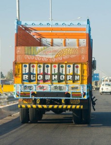
There are lots of trucks on the road. Large and somewhat over laden in my opinion, but there doesn’t seem to be much notice taken of it. Many of the coaches and trucks are very highly decorated, with incredible patterns and colours and shapes. This must be the equivalent of those well lit trucks in America. Not much power, but loads of spare paint.

I turn onto Highway 81, and as I drive past Manihahi, which sits on the edge of the Ganga river, and about half way along my journey today, I am again reminded that this land is guaranteed to be flooded every year. I debate with myself why these people would choose to live in an area that is so badly effected, EVERY year. There are no defences I can see. No walls lining the river, and this may be purely down to the fact that their money is spent on simpler things.

When I enter Malda (Formerly known by its British-named English Bazaar) it is to the south of the airport. I have to cross the border into Bangladesh, and have a good few hours to do it in, so drive straight through Malda. The city is on the ancient site of the Gaur and Pandua ruins. The British East India Company set up a factory here in 1771.

Posted in Enroute | Tagged , , , | Leave a comment

The need to plan ahead

I want to share a few issues I have been dealing with the last few days, and over the course of the last 35 days. Google maps is my help and hinderence. If it can’t plot a route, I can’t take it. Initially, I was rather naive in setting this rule, because I already wondered how I would get across the Pacific, which I will discuss nearer the time.

When I headed towards the Iran border, through Turkey, I had to research the most likely border crossing into Pakistan. [I have done this for every border along the way.] This threw up a number of issues, like, do I go through Afghanistan or not? Remember, as a virtual traveller, I can sample all of the history, culture, architecture etc., but avoid all of the problems of being shot, kidnapped or being blown up by a road bomb. I am a British citizen with a British passport, so I also consider what the British Foreign Office say for travellers, so missing out on Afghanistan made sense. There is only one official border crossing from Pakistan to India, so my route had to get me there. You may have followed my route into Nepal, which shows up the route issues I am starting to see.

I am now in india, about to pass into Bangladesh. I have already had to put some time into researching possible restrictions and routes in Burma, Thailand, Laos, Vietnam and China. Having my lovely camper is both good and bad, and I will explain these issues as we move on. Before Nepal, I only really plotted my next day. Nepal has taught me a good lesson, so I have now had to plot the next week or so, as Google maps only has very specific data on getting through to where I need to be.

One of the best sources of real information has been the many, many blogs I have read by people who have travelled these roads or crossed these borders, by foot, by bus, or by motorcycle. Something ‘European’ in me, assumed that you can go anywhere with a smile and a backpack. You can’t. If you are considering a real trip somewhere, and you live in a free country, do your research.

Posted in News | Tagged , , , , | Leave a comment

Day 33: Begusarai

The backstory of this city is like a subplot from Godfather II. Begusarai is a former stronghold for the Communist party in this region, being known as the ‘Leningrad of Bihir’. Politics has always been difficult, with many of its areas being given over to the mafias and the Communist Party of India (CPI). There have been a number of politicians who have ended up in jail over the years. The Balia Lok Sabha seat of the district was represented by a rank criminal in Suraj Bhan Singh of Mokama of the Lok Janshakti Party (LJP) who was later awarded a life term for being found guilty of killing Rami Singh of Madhurapur village while he was a sitting MP. And we, in the UK, get heated when an MP buys himself a duck house on parliamentary expenses.

Driving is precarious at the best of times, and the Indian people have an interesting interpretation of the rules of the road. There are no rules. Or so it seems. Take a look at this popular video, and note the small white car that comes in from the top, against the traffic, about a third of the way through.

[youtube http://www.youtube.com/watch?v=RjrEQaG5jPM&w=420&h=315]

The city has a lot to offer, including the Naulakha Temple, and the largest oxbow lake in Asia can be found at the Kanwar Lake Bird Sanctuary. Understandably, the river plays a big part in the life of people here, and the threat of flooding has increased over recent years. It has to be said that heavy industry is everywhere here, and this is the modern mark of this city and region.

The nearby Naulakha Temple.

The river is the lifeblood of the region.

I ‘book’ into the Meera Motel to the west of the city. It is simple, but the people are very welcoming, and I don’t feel too safe parking up and sleeping in the camper tonight. The rooms are very quaint and sparsely decorated. I will get a good night’s sleep and plot my next route. Tomorrow, I head into Bangladesh.

Posted in Places | Tagged , , | Leave a comment

Following the rivers

In order to get across this section of India, I find myself meeting rivers today. I left Gorakhpur just before nine this morning, having had an early breakfast that included Pyaz Paratha and a masala chai. At home I usually have a couple of pieces of toast with jam, but this breakfast was an eye-opener for me. Paratha is a type of bread that is stuffed with vegetables, in this case Onion, and spices and fried on a griddle. Masala chai is a tea with a mixture of indian spices and herbs.

Masala Chai

Nice warm paratha with onions

It was a little much for me, not used to the spicy start to the day, but as I set out onto Highway 27, I licked my lips and enjoyed the experience.

My journey today takes me initially south east and eventually along the same line as the Ghangra river. This river is rather intermittent and flows freely during the monsoon season [June to September], but reduces to practically nothing in some areas at other parts of the year. By the time I get to Chapra, a city on the edge of a junction of rivers, I meet up again with the Gandak River.

Just a few days ago you may recall I drove over this river in Nepal, which is known as Narayani. The river begins in Tibet and travels through the Himalayas, carving huge gorges in the mountains before heading out onto the more level ground of India. At 630 km (391 m) long, it is not the longest river in this area of the world, but is the lifeblood of millions of Indian farmers and locals, and has been for many thousands of years. It is suggested that it has shifted 80 km to the east due to tectonic movement in the last 5,000 years.

Hopefully, it won’t do any of that today, because I have to get to Begusarai before sunset.

Oddly, today, the Indian supreme court has ordered the go ahead for the long gestated plan to link major rivers in an attempt to control drought. Not many of its neighbours are in agreement, not least Pakistan. It’s a bold plan and will cost a tremendous amount of money and engineering knowhow.

Posted in Enroute | Tagged , | 2 Comments

Back the way I came

Last night I plotted the route out of Nepal and back into India, where I will head towards Bangladesh and, ultimately, China. Unfortunately, Google maps has a better idea, and after a little fact finding and numerous test plots, I find that there is a missing stretch of route data between Hetauda and Pathlaiya. For this reason alone, I have to head all the way back via Butwal and onto Gorekhpur in India. It’s a long route compared to where I could have gone, but rules are rules.

Just eat the fruit and keep driving.

I pull over before I get to Butwal and take a good look at the distant mountains. About four hours drive away is Mount Everest. Not that you can drive that way, but you know what I mean. Nepal is a country crying out to be visited. It has a rich and interesting culture and half of the biggest mountain in the world. [The border runs over the main ridge, so Tibet has the other half. I like the fact that they share it.]

I cross the Belahiya border again, which takes a little longer than the other day, due to the shear number of trunks in the way. Monday is a busy day around here. By the time I get to Gorekhpur I am ready to slip into a coma. I need a good bed, so I ‘booked’ a room in the hotel Awadh, which offers a reasonable rate for the night. Night all!

Posted in Enroute | Tagged , , | Leave a comment

Day 31: Kathmandu

Kathmandu is so much bigger than I expected. With over one million inhabitants, this is by far the biggest city in Nepal. The city stands at an elevation of approximately 1,400 metres (4,600 ft) in the bowl-shaped valley in central Nepal surrounded by four major hills. [A bit like Sheffield, but with more yellow.] Nepali is the most widely spoken language, with Nepali Bhasa spoken by the older generation. English is commonly spoken and many of the educated residence will be able to help you. What I find really great, is that the city has more than one name, depending on you you speak to. In daily use, the locals refer to it as Yen, but its medieval name was Kantipur. [Kanti is the Sanskrit word for the Goddess Lakshmi, and pur means place.]

The current name of the city is oddly named after the magnificent wooden pavillion, Kasthamandap in Durbar Square.

So much bigger than I ever expected.

I head towards the old town area of the city and visit Durbar Square, which represents the four old kingdoms of Kantipur, Lalitpur, Bhaktapur and Kirtipur. The Kasthamandap pavilion is fabulous, with its large peaks and supported roofs. The old town was mostly developed during the 1500s and widely influenced by the Hindu and Buddhist teachings.

The large range of craft and manufactured items.

There has to be a hat here for you.

Today, a Nepalese man became the smallest man in the world. 72 year old Chandra Bahadur Dangi measures just 21.5 inches (54.6 cm). Not only does he tell the officials that he has never taken any medication, he also declares that he has never been examined by a doctor before. It is unbelievable that he first left his village, Reemkholi in Dang district, some 217 miles from Kathmandu, just five years ago. This is is first visit to the capital.

I found a market where I could buy a few things for the camper and had something to eat at lunch in the Thamel House restaurant and then made my way to my hotel. I ‘booked’ a standard room for £40 at the Hotel Vaishali. It’s a little business-like, but otherwise fine for one night. The hotel has a car park, which is where my lovely camper goes for the night. After a quick meal in the restuarant, I went to my room to plot tomorrow’s journey. Getting to Kathmandu is a little out of the way for a truly round the world attempt, but the fact that I am finding that Google maps does not always offer the best routes, due to lack of data, I retire to my room to see where I need to get to tomorrow.

Posted in Places | Tagged , , | 1 Comment

Camper to Kathmandu

It’s plus about six hours ahead of London time here, and the slow journey around the world makes this change hardly noticeable. Certainly beats the stories you hear where you fly non-stop to Australia and arrive hollow.

I am making my way further along the H01 East West Highway heading towards Kathmandu. I pull over at Khaireni to fill up on fuel at the Namo Buddha Petrol Station. About an hour east of Butwal I start to head up and over the first mountain ridge and the terrain starts to get more interesting. Half way to Kathmandu, I go through Bharatpur, a large city on the east side of the Narayani river, which is very wide and one of the largest rivers in Nepal.

The Narayani river.

The bridge over the river at Bharatpur.

Bharatpur is the largest city in this area, bar Kathmandu, and has its own airport to the south. I could have flown to Kathmandu in about 25 minutes, but where’s the fun in that! Most of the road, as I near Kathmandu is high up, with long drops to the side of the road. I am on the left side of the road, so the drop is pretty close and pretty scary.

Here is a wonderful video that kind of introduces the quality of road found in the mountains. Not sure I would move very quickly in my old camper.

[youtube http://www.youtube.com/watch?v=Qq0HgYKq6F4&w=560&h=315]

Given the trouble it has taken to get to Kathmandu today, I will stay over and spend the day in the city.

Posted in Enroute | Tagged | Leave a comment